In the rapidly evolving world of connected devices, location tracking has emerged as a cornerstone of Internet of Things (IoT) applications, driving innovation across various industries, including logistics, healthcare, agriculture, and smart cities. By integrating Global Navigation Satellite Systems (GNSS) with IoT modules, devices can deliver real-time, precise positioning data, enabling use cases such as fleet management, asset monitoring, and geofencing.
An IoT module with integrated GNSS can track location data, which is fetched from GNSS satellites as NMEA streams.Users can retrieve NMEA(National Marine Electronics Association data) streams by issuing AT(Attention) commands. These commands control the module’s GNSS receiver and manage wireless connectivity through the serial interface. AT commands are text-based instructions used to control and configure embedded devices and IoT modules with integrated GNSS and cellular connectivity. The process involves powering on the GNSS, configuring settings like constellation and update rate, acquiring satellite signals to obtain position, velocity, and time data, and retrieving this data via AT commands . The module can then transmit location data to a server using protocols like HTTP or MQTT after establishing a cellular connection. AT commands, which vary by manufacturer, enable applications such as asset tracking, fleet management, and smart agriculture, with considerations for power consumption, signal quality, and antenna design.
NMEA Data: The Heart of GNSS Positioning
NMEA data provides a standardized and lightweight method for transmitting GNSS information, delivering structured sentences that encode location, speed, satellite status, and more. NMEA data, consisting of structured sentence-like strings, is typically transmitted via a serial connection. Each sentence begins with a dollar sign and ends with a checksum to ensure integrity. For example, the latitude and longitude values in an NMEA sentence provide the exact geographic coordinates in degrees, minutes, and seconds, which can be converted to decimal degrees for mapping purposes. Additionally, NMEA data includes information on the number of satellites in view, signal quality, and fix status, ensuring the accuracy and precision of the location.
One of the primary users of NMEA data is GNSS-enabled IoT modules found in asset tracking, logistics, smart vehicles, and wearables. These modules use NMEA strings to relay real-time data to cloud platforms or local processors. In fleet management systems, NMEA data helps monitor vehicle movement, detect unauthorized halts, and improve route optimization. Its intelligent use contributes significantly to power efficiency in IoT and embedded systems. In agriculture and construction, GNSS receivers output NMEA strings to enable autonomous vehicle guidance, map field boundaries, and track heavy machinery. In survey-grade applications, NMEA logs are often stored for post-processing with RTK (Real-Time Kinematics) corrections to achieve centimeter-level accuracy. In the AI and data analytics domain, location-based telemetry, when fused with machine learning models, supports predictive maintenance, traffic prediction, and geospatial intelligence.
Why Reliable Location Data Is Still a Hard Problem
OEMs developing IoT solutions that rely on GNSS face a wide range of challenges, from hardware integration to data reliability and remote management. One of the primary difficulties is achieving a fast and consistent TTFF (Time-To-First-Fix), especially in dense urban environments or areas with weak satellite visibility, which can delay the availability of accurate location data. Configuring GNSS using AT commands requires enabling the GNSS engine, selecting output formats such as NMEA sentences, setting update intervals, and initiating data streaming. Mistakes in these steps can prevent location fixes or corrupt data. Additionally, parsing and handling NMEA sentences require real-time processing capabilities and compatibility with existing software stacks. Power consumption is another critical concern; many IoT deployments, like asset trackers or monitoring solutions, are battery-powered and require GNSS modules that can operate efficiently for extended periods without recharging. Lastly, in systems where LTE and GNSS share serial interfaces, bus contention and data conflicts can occur, making it difficult to ensure reliable communication across all components. These combined challenges make it difficult for OEMs to efficiently and robustly manage GNSS operations purely through AT commands without additional tooling or cloud orchestration. The need to ensure global LTE connectivity, support for various regulatory LTE bands, and seamless GNSS operation across regions further complicates hardware design and deployment logistics. OEMs also struggle with the lack of modular, scalable platforms that can integrate GNSS with LTE communication and cloud-based monitoring cost-effectively and securely.
How Cavli C10QM Makes GNSS Integration Seamless
The Cavli C-series module C10QM, in combination with the Cavli Hubble cloud-based connectivity and modem management platform, provides a comprehensive and future-ready solution for OEMs grappling with the complex demands of GNSS-based IoT deployments. One of the most pressing challenges OEMs face is achieving fast and reliable GNSS signal acquisition across varying environments ranging from urban canyons to remote rural zones. The C10QM features a multi-constellation GNSS engine with AGNSS support, reducing TTFF in all start conditions. This ensures that IoT devices can determine accurate positions within seconds, even in signal-challenged conditions. Available in LGA and mPCIe form factors and fully integrated with the Cavli Hubble platform, it offers a complete connectivity solution for reliable and efficient monitoring across local and global networks.
Easy Integration, Longer Battery Life
For applications requiring real-time or periodic location updates, the C10QM outputs standardized NMEA sentences through its UART interfaces, making it easy for OEMs to integrate this data into their microcontrollers or processing units. The rich output includes position, velocity and time, satellite data, and more, providing all the critical telemetry needed for tracking, mapping, and analytics. This streamlines development cycles and reduces the need for external GNSS processing logic. Another major hurdle is power consumption, particularly in battery-operated devices deployed in the field. The Cavli Module supports multiple power-saving features, including eDRX (extended Discontinuous Reception), DRX, Sleep and Hibernate, allowing devices to reduce power draw while maintaining network registration. Its ultra-low power hibernate mode and efficient GNSS fix consumption are ideal for long-term deployments where energy efficiency is critical, such as wildlife tracking, smart agriculture, and asset monitoring.
Simplifying GNSS Activation with AT Commands
The Cavli C10QM module simplifies and streamlines the process of GNSS data handling for OEMs through an extensive yet easy-to-use set of AT commands. Using commands like AT+CGPS=1, the module’s GNSS engine can be quickly activated, while additional commands such as AT+CGPSGPOS?, AT+CGPSHOT, and AT+CGPSAGNSS allow developers to retrieve precise location data and optimize GNSS fix times using Assisted GNSS.
Once the GNSS engine is enabled, it streams real-time NMEA sentences such as GGA, RMC, and GSV over UART or USB interfaces, configurable via AT+GPSPORT. These AT commands abstract much of the complexity, allowing embedded applications or microcontrollers to easily acquire and parse location data. To transmit this GNSS data externally, the module supports IP-based protocols such as TCP, UDP, MQTT, FTP, and HTTP, which can be accessed through commands like AT+CIPSTART, AT+CIPSEND, or AT+MQTTPUB. However, directly managing these transmissions to multiple cloud endpoints can be difficult, especially at scale.
This is where the Cavli Hubble platform plays a vital role. Once a device is registered to Hubble using AT+HUBBLEREG, the platform enables secure, managed connectivity between the device and third-party client cloud platforms like AWS IoT, Azure, or custom backends. GNSS data collected via AT commands can be routed through the platform to these cloud endpoints using the Hubble broker, enabling seamless real-time integration without complex firmware or cloud-side configurations. Ultimately, the combination of AT command-based GNSS control and Hubble-powered cloud integration makes the C10QM module a powerful solution for building scalable, location-aware IoT systems with minimal engineering overhead.
Cloud-Based NMEA Data Transmission
What truly amplifies the power of the module is its deep integration with the Cavli Hubble cloud platform. Through Hubble, OEMs gain access to a remote device management suite that allows them to monitor the health, connectivity, and behavior of deployed devices. This drastically reduces operational overhead, especially for large-scale deployments spread across regions or countries. Hubble also facilitates secure cloud-based transmission of NMEA data, allowing real-time GNSS telemetry to be ingested by backend systems for visualization, geofencing, route replay, and historical tracking. This unlocks new value for OEMs building logistics, transportation, or industrial automation solutions that demand precise and continuous visibility of mobile assets. From hardware integration and signal optimization to power management and remote diagnostics, C10QM and the Hubble platform eliminate the traditional bottlenecks in GNSS/NMEA-based IoT product development. They allow OEMs to shift their focus from solving infrastructure issues to delivering innovative, location-aware solutions that scale reliably and perform consistently in the field.
Unlocking New Possibilities for OEMs
Cavli C10QM modules combine integrated GNSS functionality with LTE connectivity in a compact, power-efficient design,enabling NMEA data access via AT commands. With built-in support for multi-GNSS constellations and a rich set of AT commands, it enables OEMs to effortlessly retrieve NMEA-formatted location data such as $GPRMC, $GPGGA, and $GPVTG through a simple UART interface. This allows real-time geolocation features to be embedded into devices without requiring complex GNSS software stacks or separate chipsets.
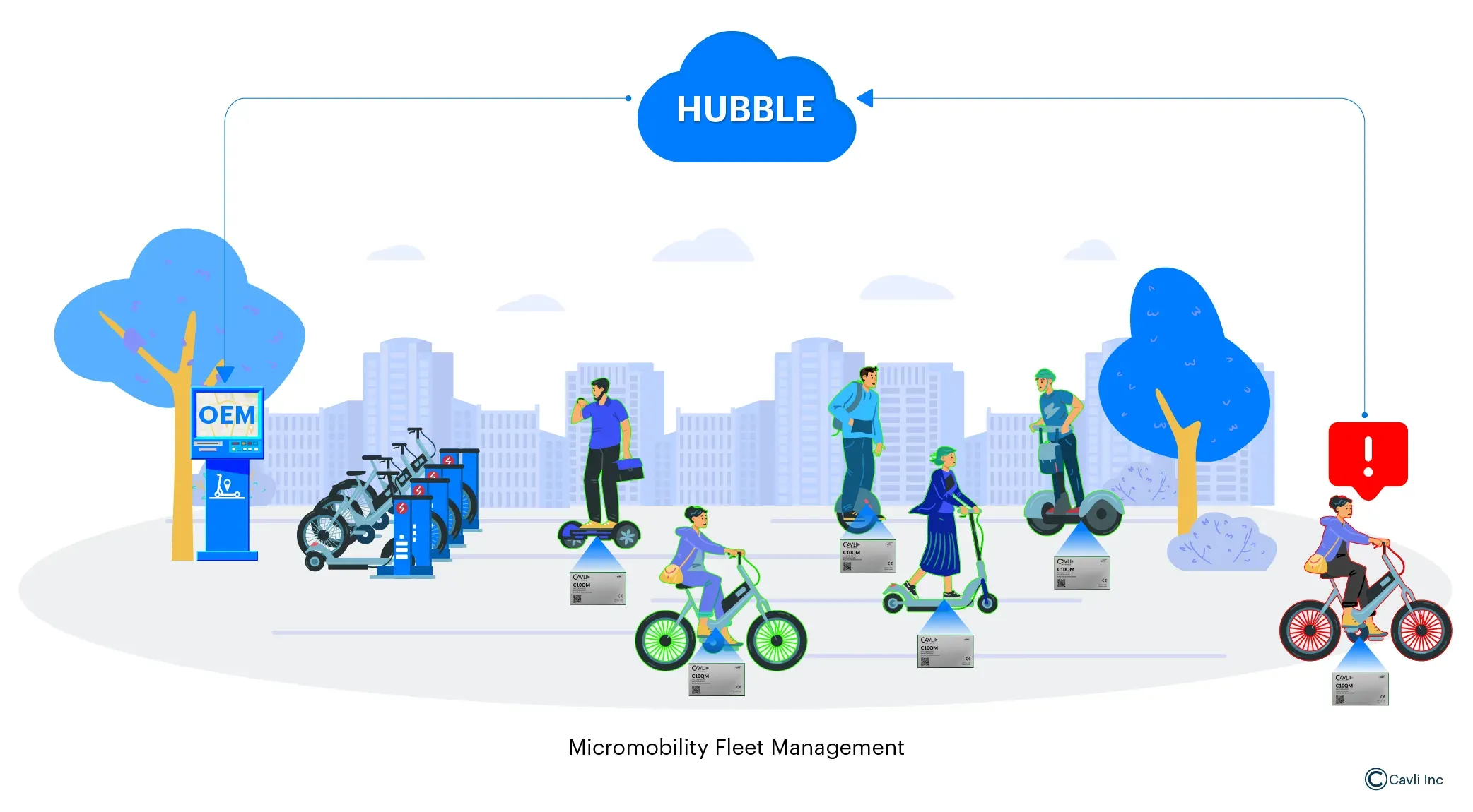
OEMs can build a future-proof micromobility system using the C10QM module to power connected electric bikes and scooters across urban environments. OEMs can develop SDK that utilizes GNSS data accessed via AT commands. These vehicles can offer real-time location tracking, geo-fencing, and route optimization while operating out of lean software stacks. The LTE connectivity enables continuous communication with cloud platforms through Cavli Hubble, allowing for centralized fleet monitoring, predictive maintenance, and theft detection. The module’s compatibility with Cavli Hubble further enhances its utility by enabling cloud-based device monitoring and remote configurations. Its low power consumption and efficient control of GNSS operations make it ideal for battery-powered smart city applications, such as asset tracking, public transportation monitoring, and infrastructure management. By offering reliable, accurate, and programmable GNSS data streaming, Cavli empowers OEMs to build scalable, location-aware products that are easy to develop, deploy, and manage across diverse urban environments.
The Practical Implications and Benefits
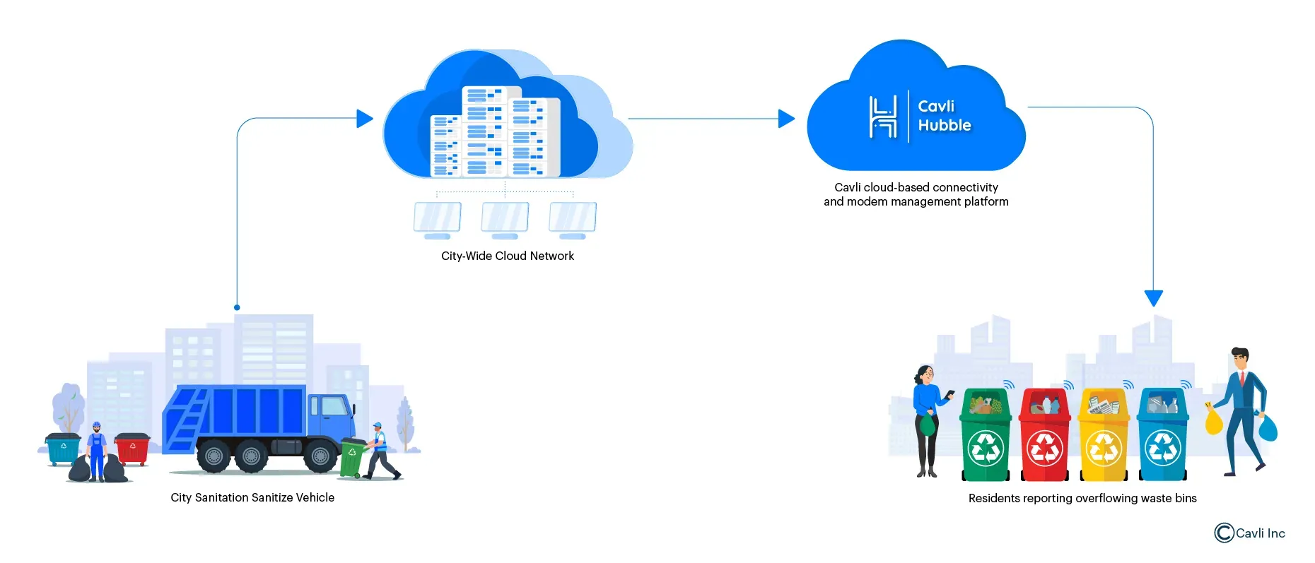
The integration of C10QM-enabled IoT systems in utility vehicles transforms smart city operations by leveraging NMEA data streams for precise geolocation and task automation. Vehicles, including waste collection trucks, street sweepers, and maintenance drones, navigate urban environments with real-time route optimization and adaptive responses to citizen requests, ensuring efficient service delivery.
Imagine a scenario where residents report overflowing bins via a city’s mobile application. The city’s waste disposal facility leverages the AT command capabilities of the Cavli C10QM module to enable real-time location tracking and control of its utility vehicles. Integrated with Cavli Hubble, a centralize cloud-based application processes incoming requests, dynamically recalculates the optimal route, and transmits updated waypoints to the nearest available vehicle for efficient task execution. The vehicle, guided by live NMEA GNSS data and telemetry, bypasses traffic congestion to address the issue swiftly, eliminating manual intervention. For city residents, the technology delivers efficient public services by optimizing waste management, snow removal, and infrastructure maintenance, reducing service delays, and enhancing urban functionality.
Proactive resolution of issues, such as overflowing bins or road hazards, fosters cleaner, safer, and more livable environments. Furthermore, residents benefit from transparent communication through timely app-based notifications about nearby utility operations and service completion, strengthening community trust and engagement. This technology’s versatility extends to applications like water leak detection and street maintenance, providing cities with scalable, data-driven solutions to elevate operational efficiency and resident satisfaction.
Closing Notes
The ability to streamline GNSS functionality through AT commands is not just a convenience, it's a critical enabler of scalable, efficient, and intelligent location-based systems. The Cavli modules stand at the forefront of this transformation by offering a highly integrated platform where GNSS control, NMEA data streaming, and cloud connectivity converge through a powerful, structured AT command interface. With just a few simple commands, developers can activate GNSS, configure fix behavior, manage power consumption, and route real-time NMEA data to client cloud platforms, all without complex middleware or firmware overhead.
AT-command-driven approach dramatically reduces development time, simplifies hardware-software integration, and allows for granular, programmable control over GNSS behavior from fixed intervals and assisted startup to NMEA stream routing. Controlling GNSS data via AT commands enhances IoT systems with greater precision, responsiveness, and smarter decision-making in location-aware applications. For solution providers aiming to build robust, future-ready products, the Cavli C-series offers not only technological depth but also practical ease, ensuring accurate positioning, reliable data delivery, and effortless integration with the broader IoT ecosystem.
Author

Soorya Kumar A
Sr. Associate- Product Marketing
Cavli Wireless